
About Us
Muhoroni Constituency
Muhoroni is an electoral constituency Number 243 in Kenya. It is a rural Constituency that makes one of seven constituencies of Kisumu County. It was established for the 1988 elections, when it was split from the Nyando Constituency. It was one of three constituencies of the former Nyando District. The Constituency has a population of about 145,764 and covers 667.30 KM2 as at November 2020. By 2017 the IEBC noted that it had 69,091 registered voters with polling stations 142.
Access NG-CDF Information on your Mobile


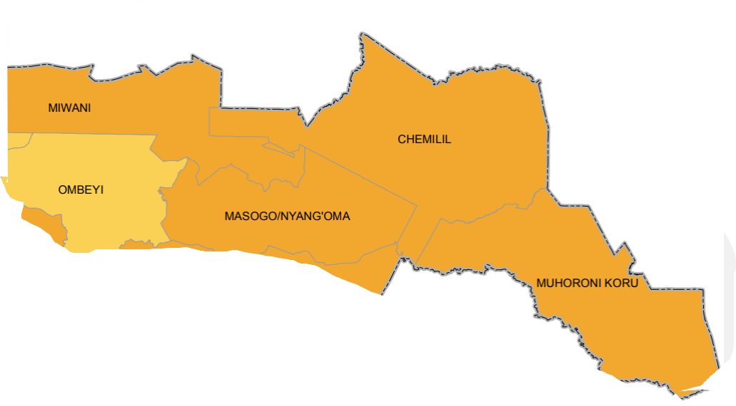
County Assembly Wards in Muhoroni Constituency :
Muhoroni/Koru Ward
- County Assembly Ward No.:
- County Assembly Ward Name: Muhoroni/Koru
- County Assembly Ward Population (Approx.): 41,157
- County Assembly Ward Area In Sq. Km (Approx.): 183.10
- County Assembly Ward Description: comprises part of
Masogo/Nyang’oma Ward
- County Assembly Ward No.:
- County Assembly Ward Name: Masogo/Nyang’oma
- County Assembly Ward Population (Approx.): 32,496
- County Assembly Ward Area In Sq. Km (Approx.): 106.10
- County Assembly Ward Description: comprises part of
Chemelil/Tamu Ward
- County Assembly Ward No.:
- County Assembly Ward Name: Chemelil/Tamu
- County Assembly Ward Population (Approx.): 26,378
- County Assembly Ward Area In Sq. Km (Approx.): 153.30
- County Assembly Ward Description: comprises part of
Miwani Ward
- County Assembly Ward No.:
- County Assembly Ward Name: Miwani
- County Assembly Ward Population (Approx.): 19.426
- County Assembly Ward Area In Sq. Km (Approx.): 132.30
- County Assembly Ward Description: comprises part of
Ombeyi Ward
- County Assembly Ward No.:
- County Assembly Ward Name: Ombeyi
- County Assembly Ward Population (Approx.): 26,307
- County Assembly Ward Area In Sq. Km (Approx.): 92.50
- County Assembly Ward Description: comprises part of